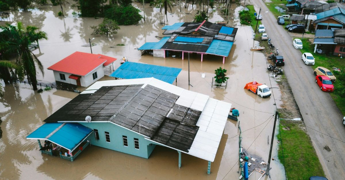
If you live in Hayward, especially near the shoreline or low-lying neighborhoods, you might be facing a growing and silent threat: sea level rise. Once thought to be a distant concern, climate change has fast-tracked its timeline. In 2025 and beyond, flood risk is no longer just a prediction — it’s becoming a real possibility for thousands of residents.
Thankfully, the Hayward flood risk map provides a crucial tool to understand which properties, streets, and neighborhoods are most vulnerable. But are enough people paying attention?
Why Sea Level Rise Matters in Hayward?

Hayward is situated on the eastern edge of the San Francisco Bay — a region directly exposed to rising tides, storm surges, and groundwater flooding. According to climate scientists, the Bay Area could see sea levels rise by up to 2 feet by 2050 if current emissions trends continue.
For Hayward residents, this could mean:
- Property damage from flooding
- Soil erosion and saltwater intrusion
- Disruption to transportation and utilities
- Higher insurance premiums or loss of coverage
And the threat isn’t only for waterfront homes — inland neighborhoods connected to creeks, storm drains, or old infrastructure are also at growing risk.
What Is the Hayward Flood Risk Map?

The Hayward flood risk map is a digital tool and city resource developed using FEMA data, local topography, and climate models. It shows areas most at risk of flooding from storms, king tides, and sea level rise — now and in the future.
Where to Find It:
Residents can access the map online through the City of Hayward or Alameda County websites. You can:
- Search by address or parcel number
- View color-coded zones showing current and future flood risks
- Download risk assessments and insurance suggestions
Areas Most at Risk (According to the Map)
Based on the latest projections, here are key Hayward neighborhoods marked with moderate to high flood risk:
| Neighborhood | Flood Risk Level | Main Concern |
|---|---|---|
| South Hayward | High | Low elevation near marshlands |
| Eden Shores | Moderate–High | Close to shoreline & levee system |
| Industrial Parkway | High | Surrounded by stormwater basins |
| Burbank Area | Moderate | Affected by creek overflow potential |
| Jackson Triangle | Moderate | Drainage issues during heavy rains |
What If Your Home Is in a Flood Zone?

If the Hayward flood risk map shows your home in a vulnerable area, don’t panic — but do prepare.
Here’s what you can do:
- Get flood insurance even if it’s not required. Most homeowner policies don’t cover flooding.
- Elevate utilities like water heaters, HVAC systems, and circuit breakers above projected flood levels.
- Create a flood action plan with evacuation routes and emergency supplies.
- Stay informed during king tide and storm seasons via Nixle alerts and city advisories.
Hayward’s Flood Defense Efforts
The city isn’t standing still. Hayward has joined several Bay Area initiatives to adapt to sea level rise and reinforce infrastructure:
- Bay Trail levee upgrades are underway to hold back storm surges.
- The Shoreline Master Plan outlines long-term flood prevention including marsh restoration.
- Investments in stormwater pump stations are helping drain excess water faster.
- Green infrastructure projects — like rain gardens and permeable pavement — are being built to reduce runoff and pressure on aging systems.
However, these efforts require time and funding. The risks will likely increase before they improve.
Real Estate and Financial Impact
With increased flood risks, homeowners and renters in Hayward may face:
- Property value fluctuations in at-risk areas.
- Stricter loan conditions or flood disclosures during sales.
- Higher costs for insurance or renovation compliance.
Real estate experts recommend reviewing your home’s elevation certificate and speaking with insurance agents to understand future liabilities.
How to Check Your Flood Risk (In 2 Minutes)
Here’s a quick guide using the Hayward flood risk map:
- Visit the City of Hayward website or FEMA Flood Map Service Center.
- Enter your full address.
- Use the legend to interpret flood zones:
- Zone AE = High risk (mandatory insurance in most cases)
- Zone X = Moderate or minimal risk
- Explore nearby creeks, drains, and levees to understand surrounding threats.
- Download your flood risk report for reference.
Conclusion: Don’t Wait for the Water
Sea level rise is no longer a far-off theory — it’s a present challenge. The Hayward flood risk map is your front-line tool for understanding how this issue affects your home, your finances, and your safety.
Being prepared isn’t about panic — it’s about smart, early action. As Hayward continues to develop and grow, we all have a responsibility to stay informed and ready.
Whether you’re a homeowner, renter, or investor, now is the time to look up your address, evaluate the risk, and take steps to protect your future.
Hayward Housing and Climate Update
FAQ’s
Q1. What is the Hayward flood risk map?
It’s an online tool that shows flood-prone areas based on FEMA and city data.
Q2. Is flood insurance required in Hayward?
Only in high-risk zones, but it’s strongly recommended in moderate-risk areas too.
Q3. Are all homes near the Bay at risk?
Not all, but many low-lying areas and those near creeks are vulnerable to future flooding.